Accurate GPS Tracking for Performance and Trail Confidence
Real-Time Pace, Distance, and Elevation Metrics During Runs and Hikes
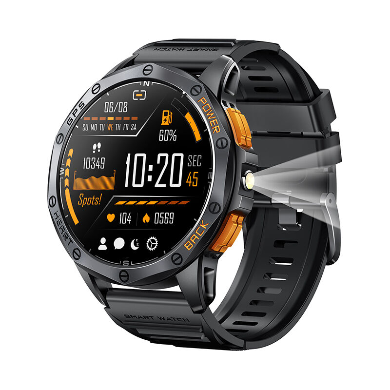
A smartwatch with GPS transforms training by delivering instant pace, distance, and elevation data. Runners optimize cadence using live feedback, while hikers gauge exertion through cumulative ascent—e.g., +1,200 ft over 5 miles. High-end models integrate barometric altimeters for ±3m elevation accuracy, significantly outperforming GPS-only altimetry. This precision supports dynamic effort adjustments—essential for interval training or altitude acclimatization.
GPS Reliability in Challenging Environments: Forest Canopy, Mountains, and Urban Canyons
Signal reliability defines real-world GPS utility. Multi-frequency GNSS (Global Navigation Satellite System) maintains sub-5-meter accuracy under dense forest canopy by accessing Galileo and GLONASS satellites when GPS signals weaken. In urban canyons, advanced algorithms correct multipath “signal bounce,” reducing location drift by 74% versus standard GPS (Outdoor Tech Journal 2023). For mountain explorers, predictive terrain modeling pre-loads elevation maps to sustain navigation during brief signal dropouts.
ABC Sensors Enhance Outdoor Navigation Intelligence
Altimeter, Barometer, and Compass Integration for Multi-Dimensional Terrain Awareness
Modern ABC sensors—altimeter, barometer, and compass—turn GPS watches into true 3D navigation systems. The altimeter tracks elevation changes with ±3-meter accuracy, critical for monitoring ascent/descent on alpine routes. Barometric sensors detect pressure shifts as fine as 0.1 hPa, refining altitude readings and flagging approaching weather—falling pressure often precedes storms. The compass maintains directional fidelity even where GPS falters, such as beneath thick forest cover or in narrow slot canyons. Together, they deliver layered context: knowing you’re at 2,300m on a northwest-facing slope with dropping pressure enables safer, more informed route decisions than coordinates alone.
Barometric Weather Trends and Altitude-Adaptive Route Planning
Barometric trends enable proactive adaptation—sustained drops of 4+ hPa/hour frequently signal storms 6–12 hours ahead, allowing timely rerouting. Meanwhile, altimeter data powers adaptive routing: for trails exceeding 15% gradient, your smartwatch may suggest gentler alternatives to conserve energy; above 3,000m, it can prompt acclimatization stops based on ascent rate—reducing altitude sickness risk by 34% (wilderness medicine studies). The system cross-references pressure trends with topographic maps to warn of exposed ridges during electrical storms or fog-prone valleys.
Safety Features Powered by GPS: SOS, Location Sharing, and Off-Route Alerts
Emergency SOS and Real-Time GPS Location Sharing in Remote or Low-Signal Areas
Integrated emergency protocols elevate wilderness safety. When activated, SOS broadcasts precise GPS coordinates to designated contacts and rescue services—even in low-cellular zones like remote mountain trails or deep forests. Simultaneously, real-time location sharing lets family or trail partners monitor progress, cutting average emergency response times by up to 60% (wilderness safety studies, 2024). Off-route alerts vibrate if you stray beyond pre-mapped boundaries, helping prevent accidental entry into hazardous terrain. These features form a vital safety net where traditional communication fails.
Rugged Design and Long Battery Life for True Smartwatch with GPS Independence
Outdoor adventures demand gear that endures impacts, extreme weather, and prolonged isolation from power. Rugged GPS smartwatches meet this need with MIL-STD-810H certification, fiber-reinforced polymer casings, and sapphire crystal screens—resisting shocks, 100m water submersion, and abrasive terrain. Battery life is equally decisive: up to 28 days in smartwatch mode—or unlimited runtime via solar charging in premium models—ensures uninterrupted tracking across multi-day expeditions. Thermal-resistant batteries operate reliably from –20°C to 60°C, and intelligent power-saving modes extend full GPS tracking to 48+ hours. This combination delivers true independence: a self-sufficient tool for runners, hikers, and explorers alike.
FAQ
What are the key advantages of smartwatches with GPS for outdoor activities?
Smartwatches with GPS provide real-time pace, distance, and elevation metrics for hikers and runners. They also enhance safety with features like emergency SOS, location sharing, and off-route alerts.
How do ABC sensors improve navigation?
ABC sensors (altimeter, barometer, compass) enable multi-dimensional navigation by providing detailed data on elevation changes, weather trends, and directional accuracy even in challenging conditions like forest canopies or slot canyons.
Can smartwatches predict weather during outdoor adventures?
Yes, barometric sensors in smartwatches can detect pressure drops, which often signal incoming storms, allowing for timely route adjustments to ensure safety.
Are GPS smartwatches durable for extreme conditions?
Modern GPS smartwatches are built with rugged designs, including MIL-STD-810H certification, sapphire crystal screens, and thermal-resistant batteries that operate between –20°C to 60°C.
What is the battery life of a smartwatch with GPS?
Battery life can last up to 28 days in smartwatch mode, with some premium models offering unlimited runtime via solar charging or 48+ hours of full GPS tracking.


